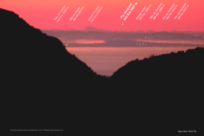
Current Guinness World Record
Longest Line of Sight
| Distance | 443 Kilometers |
| By | Mark Bret |
| Camera | Panasonic Lumix FZ72 @ ISO100 – 1/250 |
| Lens | Integrated Zoom @ 1200 mm (equiv.) – f./2.8 |
| Date | July 16th 2016 |
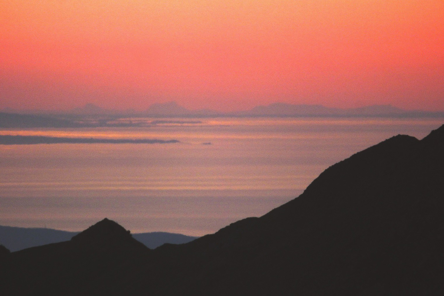
Portraying the silhouette of the Barre des Ecrins from the most distant possible summit of the Pyrenees and get a new World Distance Record has been for us the last most recent target.
The result is counted in the image: a view from Pic de Finestrelles (2.820 m.) to the Alps.
Want to try yourself? Don’t forget to check our recommended cameras!
Since we managed to do for the first time a picture of the Alps from the Pyrenees, we try to want to do portraits to other peaks, something more remote.
View the Ecrins in the broad daylight in mid-February thanks to exceptional weather conditions, with help also of a polarizing filter was a huge satisfaction after previous attempts, sometimes collectively as well as individually. I had already portrayed in January of 2015 the Ecrins mountains alsom but with a very faint result.
Last July, from a more distant peak than on previous occasions (in April I get it also from other summit before sunrise) and good weather forecast, it made a great success of visibility. The Barre des Ecrins relatively clearly manifested backlight of a sun in close position below the horizon.
To his left, other peaks of the Alps we also seen. Refractive favorable circumstances allowed to view some other peaks, even that more distant than the Barre des Ecrins. Pic Gaspard, 443 Km, is what has given us this time the brand new World Record of distant photograph of landscapes in our planet.
Some pictures and ilustrations:

|
|


Ulrich Deuschle has a simulation of this view here:

You can also have a look at an interactive view of this simulation here
MORE EXTENSIVE REPORTS:
You can read more extensive explains in these other two webs:
https://horitzonsllunyans.wordpress.com (catalan)
https://ventanasdeaire.wordpress.com (spanish)
PHOTOS IN FLICKR:
You can seee a lot of more pictures of that day in this àlbum:
https://www.flickr.com/photos/markbret/albums/72157668339813284
And more pics to the Alps of Pyriness of the same author (me) in other albums:
https://www.flickr.com/photos/markbret/albums
Facebook: facebook.com/horitzonsllunyans Twitter: @finestresdaire
AFTER:
We are sure that other records will come soon. From the Pyrenees the options are almost finished but any attempt to increase the distance is still possible if atmospheric conditions are especially favorable refractive exceptional transparency. We’re on that. By the other hand, also, maybe next arises from another continent, from another mountain range of our planet. We think it’s really probably.
We will inform you.

It would be a fun project for a physical geographer to figure out where in the world this could be expanded even further. There are additional atmospheric effects like thermal inversions that create a “mirage” (or Fata Morgana) that could even possibly extend this beyond the normal “light bending beyond the horizon” effect.
LikeLike
Lol. Prove a “curved” horizon. Horizon=horizontal. This picture was possible because of the amazing zooming lens the camera offers and that’s all. Observe the truth and then you’ll see the… Flat earth!!!
LikeLiked by 2 people
This is 100% proof that our earth is indeed flat!
LikeLiked by 2 people
Horizon is “flat” because without hills at every point horizon is equally away from observer, and apparent horizon dip is equall all the way around. When you go upper you see further. Do you really think that your vision drastically improve with altitude?
LikeLike
The Earth curves at around 600 to almost 1000 miles out the intire USA curves at the middle of the US almost 1000 miles I know the Earth is round!. Pie?.Giza Pyramid?.com on!.
LikeLike
That photograph actually proves global Earth: https://www.youtube.com/watch?v=ZfeeN90XiBQ&t=14s
LikeLike
Yeah, no. Check the elevation and the height of those mountains in the photo. They are plenty high for this photo to have happened.
LikeLike
Photo is impossible on a FE. Lol
LikeLike
That is the way I read it : Horizontal or you would not see or capture it with a photograph.
LikeLike
So where is the 4000+missing curviture at?
LikeLiked by 2 people
The mising curvature is only around 100 m. Did you ever go to elementary school? Heard of trigonometry?
LikeLike
Shouldn’t that peak be below 50416 ft of curvature? How is this possible
LikeLike
Pingback: Flat Earth Theory: World Record Zoom Pic Is 275 Miles – No Curve! | Verum Et Inventa II
This is awesome! One more proof we live on a flat plane. 😃 Where is the curvature? 😀
LikeLike
The Earth is flat
LikeLike
Amazing photos. Just proves the earth is flat and not a big ball…!
LikeLike
That damn flat earther’s are trying to use your photos as evidence the earth is flat.
LikeLike
Pingback: THE CURRENT WORLD RECORD FOR THE GREATEST DISTANCE WITH A ZOOM PROVES YET AGAIN THE WORLD IS FLAT | Our Way IS the Highway
How is this possible on a globe Earth? At 443 km, the curvature of the Earth would be 15,367 meters. How can you possibly see the subject if it’s that far below the curvature of the Earth?
LikeLiked by 3 people
Hello Mareta. As we have explained on previous occasions, the reason is in atmospheric refraction. Thanks for your interest.
LikeLiked by 1 person
So are you saying that if this shot is taken during midday for instance we won’t be able to see the opposite land?! I doubt!
LikeLike
It’s a lot of more difficult during the day because It is much more improbable to see silhouettes very far away in full daylight than in backlight conditions before sunrise or after sunset, a much more transparent air is necessary but even with very clear air, the “atmospheric extinction” (technical name) it’s produced. The cause of the difficulty is the dispersion of light by the atmosphere, both due to the atmospheric molecules themselves (Raleigh scattering) and due to aerosols (Mie scattering); The dispersion in the intermediate sector between the observer and the distant mountains is so intense that it prevents the distinction of the silhouettes. It happens as if in a show, the lights are not oriented towards the stage, but towards the whole of the room.
If there is snow, the intense reflectivity that produces compensates a little the negative effects commented above.
LikeLike
Mark you really like giving answers just for the sake of it? Youre talking about +15km that refraction is accountable for…. Mareta asked a legit question and you answer it bluntly with a belief based reason, nothing exact nor scientific. Shes asking why does -2x-3= 6 and you explain it by “math”. What a joke. At least say the reason is a superior mirage. Then prove it because the picture clearly doesnt depict such a thing.
Regardless of this insulting answer I’ll try to explain why you can see so far, curved or flat earth.
Mareta, I dont think you can calculate what the drop in height at that distance is simply because we dont have any info about what height the photo has been taken from. if we accept the height as being 2820m the drop at 443km would be 5km with visible horizon at 190km. so even at this height the highest peak would still be hidden by 900m at least.
Now Mark Bret said “atmospheric refraction” is the reason you can see the peaks. So just do the math to see what variables you need for more than 1km of mirage. Its probably even more since you dont see just the upmost part of the peak,
LikeLiked by 1 person
Hello. In the image there was no superior mirage. The refraction was high but there was no inversion of temperature that made the curve of light of one part bend more than the other and produce a mirror.
To be able to observe hundreds of meters more of mountain than what would be logical in a rectilinear vision has no mystery above all for long distances. The sun itself, for example, due to refraction, most of it is always displayed higher than what is on the horizon when sunrises or sets. If we think about the measurements of the sun …How many? Thousands of tens of thousands of kilometers of the sun are the ones that are higher than their position on the horizon, much more than a few meters from the Alps.. It’s a matter of angular degrees, not vertical kilometers.
LikeLike
Can you videotape an experiment showing that light bending hypotheses?
if you need a strong magnet i’m sure Cern can show you how to use it in place of gravity…. because we can replicate assimilate and duplicate anything *BUT* gravity … just a thought
LikeLike
So what you are saying is that you didn’t actually photograph the mountains but a mirage of the mountains? Isn’t everything that is refracted (or miraged) upside down? And the mountains that are refracted are lift up by 15km? That seems impossible!
LikeLiked by 2 people
Wow refraction is magical
LikeLiked by 2 people
This is heliocentric bs…..prove it!!!
Just because the majority don’t investigate things, the growing minority are not the dumb asses they are made out to be….
This proves without doubt the earth is flat, that we were created, are that our ancestors created a theory to keep us oppressed and in slavery.
Instead of feeling we are an accident, we should be celebrating everything that has ever existed….
I’m not mad, dumb, a conspiracy theorist, or more importantly a follower of the religion of science.
I have eyes, a brain, and I am able to do honest research…
Instead of berating and belittling, Prove any theory about our globe planet, without relying on a lab, or the use of an imaginary force….??
Challenge set.
LikeLike
Yeah, its impossible on a earth thats circumference is 6700km.
LikeLiked by 1 person
The Circumference is 40,075 km.
LikeLike
You are not going to measure from 0 height. You are already on mountain’s peak…
Try https://dizzib.github.io/earth/curve-calc/?d0=440&h0=3500&unit=metric for explanations…
LikeLike
He did account for his elevation. 9252 feet = 2820 meters
LikeLike
Im wondering the same. If this is from refraction or a mirrage then its not the world record photo for distance. How can you claim that if its suposuddly a mirrage or light retraction . FLAT EARTH unplug peopleand wake up
LikeLiked by 1 person
Maretta, where the hell did you get the 15 km figure from? This is wrong. Draw this out properly, take height of both points into account, do trigonometry. I did, the mountain is only “hidden” by 200 m, which is well within the realm of being explained by atmospheric refraction on that distance. Basic elementary school math.
LikeLike
67 / ZOOM 162,4 km! = 100,911 mil! – YouTube
mountain.sky@centrum.cz
LikeLike
At the height the photo was taken from, he curvature at 440km is only 4919m. So that’s only about an 800m difference. And at different areas on the earth it doesn’t follow the precise mathematical curvature formula. There are plenty of flat areas, high areas and low areas. The earth isn’t a Walmart ball. It’s a globe. There’s a big difference between and globe and a ball. (Which is why flat earthers like to say that we think we live on a ball.)
LikeLike
“At 443 km, the curvature of the Earth would be 15,367 meters”
No, it wouldn’t be 15 367 meters. It would be 5 038 meters, refraction over a distance of 443 KM can be responsible for 2-4 KM so we should see 1-3 KM of the mountain depending on the day.
That was easy.
Can any flat earther explain to me HOW THE TALLER MOUNTAIN THATS FURTHER AWAY APPEARS TO BE SMALLER THAN GRAND FERRAND?
It doesn’t make sense on a flat earth with those distances.
Why don’t we see those mountains from sea level on a flat earth? It should be easy to see lighthouses with a naked eye from 100km. And yet you can’t see them with any telescope or zoom over a longer distance.
What about every time when I’m visiting the beach and my camera can photograph wind turbines that are on the land on the other side, and they appear like they were over half under water?
LikeLike
Pingback: There is no Debate - Flat Earth Flat Earth Theory Proof Flat Earth Society - Flat Earth Theory
Amazing, these people have alot of patience. The earth is a wonderful place and this picture shows us so.
LikeLiked by 1 person
Pingback, the Earth is not flat. The flat Earth model does not work from all the angles you can look at it. But for that, you have to look.
LikeLike
Shortcut to this page: tinyurl.com/PicGaspardFE
Also see: tinyurl.com/FElinks
LikeLike
Wow! This undoubtedly proves that the Earth surface is flat. Thank you.
LikeLike
Pingback: Hard Bewijs » Current world record of distance landscape photography
Pingback: Hard Bewijs » Wereldrecord afstandsfotografie op 443KM
Qual a altitude que foi tirada a foto…
LikeLike
La terre e plat, the earth is flat, a terra e plana… 🍐💫🌎 how can we see a mountain of 9500 feet when it should be hidden under 50000 feet of curve on a 25000 mile ball?
LikeLiked by 2 people
Maybe because mountain from where which these pics were taken is way smaller than Alps.
LikeLiked by 2 people
I can’t believe I’m actually responding but anyway. I drew a 6371km (too bad using metric) radius circle (approximation of the Earth) in a CAD program. Then I put a point at either end, 440km apart. Next I went up 2.82km from the curved surface on the left end and 4.1km up on the right. Drawing a line between the two peaks does indeed cut through the surface (0.34km deep), appearing to show that one peak should not be visible from the other.
HOWEVER, a line of sight through the atmosphere is not straight! Refraction makes it curved and the apparent difference in height = 1.1 * 10^-8 * d^2. At 440km, this means the terrain appears 2.13km higher than it is. Therefore, I went up 2.13km above the peak on the right and the LOS now passes 0.72km ABOVE the surface, meaning it IS visible. This method is not 100% accurate because the actual LOS is curved. Actually, because the LOS curves downwards (from the vantage point on the left), more than the top 1450m of the mountain (on my diagram) would be visible.
LikeLiked by 1 person
Earth is flat. Refraction is always constant.
Such an experiment does not exist:
– Experiment with 0% refraction: object not visible geometrically and not in the field of view
– Experiment with> 0% Refraction: Object not visible geometrically, but in the field of view
And here an other unbelievable picture. You can see Feldberg in 402 km in direction 252°:
http://www.panorama-photo.net/panorama.php?pid=14467&ds
LikeLiked by 3 people
Wonderful picture of Alps Engel Benjamin! and good definition. We would like to make an article about this photo if we can conctact with the autor.
But I don’t get to see the detail that you refer at 402 kms. With simulator it seems that the most distant silhouette can not more of 293 Kms, even with high refraction..
LikeLike
Beautiful Picture! On a planet we are not able to see this Mountains, according http://earthcurvature.com/ the mountains should be with a distance 446 km, 15 km lower behind the curve…..research it 🙂 Im wondering if we can brake this record 🙂
LikeLiked by 2 people
Some information for the Feldberg-picture:
The horizontal shows that the four peaks must be farther away than the 266 km and 3016 m high Sulzkogel in the picture:

The summit on 252° looks very enlarged like the Feldberg:

And here the height profile from recording location to Feldberg:

(There is nothing else)
So I think:
on about 252°: Seebuck and Feldberg;
on about 251°: Spießhorn, Herzogenhorn, Grafenmatt;
on about 250°: Ober Habsberg, Botzberg, Schnepfhalde;
on about 249°: Staufenkopf
But maybe you have/get some more detailed information.
LikeLike
Hello Ben Trier. Interessant your suggest with these details. Anyway I’ve seen simulations and for to see Feldberg it would be necessary a super big refraction value (in concret 7’4 decimals more in relation to standar value of simulator of Ulrich) that it seems are not present for the rest of silhouettes of panorama, moreover in case of that big refraction we hope that we could see superior mirages in the scene and there aren’t presents in the picture. Anyway this arguments this if we consider that refraction (with the curved Earth) is necessary, of course. If we think that the Earth is flat, then obviously there are more possibilities for it, but also in that case I think we should see other silhouettes also more distant in the other sectors of the azimuths ..that are not presents. It’s difficult to know if that the silhouetts may be smokes (like a electric power station at left) or silhouetts of closer moutains. Problem is the mist in low levels for compare with other forms. For me is difficult to believe that are very far like Feldberg, although I don’t totally rule out the possibility. Thanks.
LikeLike
Laura, good answer, but where did you get the data about temperature and humidity in that day, needed to calculate the refractive index? Maybe there are more variables that i dont know from the top of my head…
LikeLike
it’s not accurate because all throughout history scientists have taught light DOES NOT bend, Now we’re taught that ALL light reaching our eyes is bent…. do we not have any scientific evidence that doesn’t do a 180 when academia sees fit to change it…
I no longer trust anything mathematically provided by non-experimental scientists. Tesla is right, scientists wander off through equation after equation till they have something nowhere near reality.
No matter what, whom, or how many claim a thing. If experiments prove otherwise … It’s Wrong!
LikeLiked by 1 person
Awesome pic ! thanks for sharing.
A while ago I heard from this record (sorry, couldn’t find a reference in english) http://www.biobiochile.cl/noticias/cultura/cultura-entretencion/2016/07/19/nuevo-record-mundial-de-fotografia-a-distancia-inaugura-exposicion-en-planetario-chile.shtml
which if the article is right, was taken at about 490 km. The pic is less captivating though.
LikeLike
Hello Elias. Yes but it was wrong it. Here is a letter that I sent in response to Roberto, who defended a whole series of previous things, in a forum. It’s in spanish: http://beyondhorizons.eu/2016/08/03/pic-de-finestrelles-pic-gaspard-ecrins-443-km/hola-roberto/ You can ckick in the tittle for to open the PDF.
In short, he confused the Pico Mercedario, with another mountain closer. This can be seen unmistakably in the panoramic simulations generated from the point from which he made the photographs.
LikeLike
What happened to this? How could it be possible to see 443km away when the horizon would block it? is it light making a mirage? Why isn’t this used as a main citation for flat earthers in their arguments? How come no one has debunked this? How do they know that’s the right mountain?
These seem like stupid questions but I haven’t heard them addressed under this “world record”
Where can I find this record besides on this website? Guiness book?
Am I restarted to be asking these questions? I feel all of them should be answered by way of accreditations already displayed on this site, maybe a picture of ya’ll with a plaque?
LikeLike
Hello Gumbo. Atmospheric refraction allows in a curved earth, reliefs beyond the horizon can be seen above. I think it has no mystery and is something we do not usually explain because we give it as obvious. In any case there are several entries on the web in which we explain some examples with diagrams. Anyway thanks for your interest and opinion.
LikeLike
Yes, you are restarted
LikeLike
Pingback: Leituras de 28Julho2017 – daily digest news
Très belle visibilité, de distance bien supérieure au Mont Blanc vu du Puy de Dôme (302km) ou du Plomb du Cantal (332km)
LikeLike
Pingback: The Gulf of Lion, Alps and Mont Ventoux on a winter morning from the Bastiments peak (Pyriness). | 436 km. | Beyond Horizons
Pingback: Quick Fact: The current world record of distance landscape photography is a... - Quick Facts
Well, I want to say, thank you for sharing this picture, second, I want to say that I am very impressed that you climbed a mountain, reached so high and were able to take such beautiful pictures. I currently believe the earth is flat, however, a commenter said that these pictures were due to refraction. I want to read and learn as much about refraction as I can, and your pictures and argument for refraction means more to me than anything I have seen in the “media’ or whatever space agency has shown to us.
Thank you again and I hope mountain climbing like this makes you happy! And perhaps I will look in to doing a similar hobby myself!
LikeLike
Taking away nothing from the person who shot this nice image, reading about the so called “…refraction ” is the same as seeking “science” from NASA. The more you consume their info the more you are isolated from reality. Arguably, atmospheric refraction was invented to hide the flat earth fact
LikeLike
I understand the way atmospheric refraction works as I have been studying views for quite a few years. Ulrich Deuschle’s website is an excellent source for creating panoramas and using different levels of refraction. I saw the reference to superior mirages – I know of course that the Ecrins range was seen in normal very clear conditions, but when a superior mirage causes mountains below the horizon to appear I have heard they normally appear distorted.
I am not sure what the refraction coefficient would be for superior mirage images to appear.
LikeLike
First of all, congratulations to Marc and his friend for taking the above picture (as far as I know this is the most distant view possible in the Europe). Second, I would like to take a note of refraction which is neither a kind of magic we don’t understand nor an invention of malevolent organizations. Refraction results from the fact that light travels as electromagnetic wave. We can see and read and take the pictures with our cameras (lenses!) owing to refraction :-). This phenomenon occurs when the refractive index, which describes the speed of light in given environment, depends on actual location. The refractive index of air decreases to 1 with increasing altitude, because the concentration of molecules decreases. That is why the line of sight in the atmosphere is curved downwards.
So sorry but long distance observations do not prove that the Earth is flat :-).
LikeLike
No but constant observations around the world, coupled with the fact that nobody has been able to visually demonstrate the geologic curvature, when It should be geometrically, do indeed confirm a flat plane. The only time curvature is ever ‘demonstrated’ is via fish eye lens, Hollywood entertainment and/ or space agencies…. Accepting such claims, without even conducting a superficial investigation makes one a victim of authority fallacy, which is unscientific and gives rise to arrogant egos
LikeLiked by 1 person
Pingback: World distance photography winner proves the Earth is flat – Unreally
Pingback: Welcome to Beyond Horizons | Beyond Horizons
Pingback: World Record Distance – Picture of Mountains 275 Miles Away – Flat Earth – Southern Israelite
Can you videotape an experiment showing that light bending hypotheses?
if you need a strong magnet i’m sure Cern can show you how to use it in place of gravity…. because we can replicate assimilate and duplicate anything *BUT* gravity … just a thought
LikeLike
The picture is from such an unbelievable distance. That being said, there are two reasons why this yet another proof of a flat earth. This massive distance puts the peaks at a small descending angle inward to the center of your vision, and if on a flat earth, wherever you are on earth, you are at the top of that said earth, compared to everyone other person at every other place on earth, and if high enough, looking down, at all angles 360 degrees to your perspective. Looking down a hallway in a long hotel room, the distance could be a quarter mile let’s say, and eventually the ceiling and the floor will converge in the center of your vision. Why? Even though both of them are not at your eye level originally, they will eventually join as such in your terminating view point at the horizon line at the limit of your view. If you could zoom in, they both would appear to expand back out again. They both are flat surfaces and stay at center view. The same exact view in the range finder is happening no matter the distance. Even as they photographer is some odd thousand feet in the air, his horizon view is center vision. If he rose up to 35,000 ft, the horizon would still be center vision. And in this picture, nothing is more obvious to someone who understands this a long distance shot between two tall points on a flat surface, not looking down the curve, where everything should be lower than your center of vision. The higher you go up on a ball and the further you look down it the lower your looking. This is not a globe. This is a flat fucking earth.
LikeLiked by 2 people
Impossible photo on a FE. Parallel lines never converge let alone cross over each other – even at a distance of 440km.
LikeLike
Pingback: 2:00PM Water Cooler 11/6/2017 - Daily Economic Buzz
Pingback: Interesting Links for 07-11-2017 | Made from Truth and Lies
Get a shot from the top of Rupes Nigra…
On a clear day there’s a good chance you would be able to get the Ross Ice Shelf in the viewfinder.
LikeLiked by 1 person
Pingback: How the Flat Earth Seed was Planted into my Soul – With Just One Simple Comment | Flat Earth Vlog
Pingback: World record of distant landscape photography | Blog of Leonid Mamchenkov
Pingback: How is it Possible to See This on a Sphere Earth? – Earth Shape Discussions
Pingback: 443 km pour ce record du monde de photo de paysage distant
Put the figures into the curvature calculator. Distance: 443km. Viewing height: 2820m. Target: 4102m. Metabunk.org says 5038.19m is hidden, assuming target is at sea level. But it’s not, so 5038.19 minus 4102 (target height) and we get 936.19m (should be hidden below curve). That’s a lot!
Tell me if I’m wrong with my calculations. They don’t deal with ‘refraction’ which is another story.
LikeLike
Actually the hidden hight is just of 3800m not 5038m
LikeLike
at 9272ft, any object 275mi away would need to be over 3mi high to even begin peeking over the horizon. Refraction won’t help even if light bent in the correct direction to make it possible but it is an ad-hoc excuse anyway. The image in not distorted or wavy.
LikeLike
well first this shot sucks, then ti makes me laugh when they brag about it being a distance record!! They must have missed all the videos showing the same camera filming the moon craters which are just a tad farther than 473kms…
LikeLike
Yes, looking through a mere 100 kilometres of ever-thinning atmosphere is a lot clearer than 400 km through the thickest part of the atmosphere.
And yes, light bends or we would still be using pinhole cameras.
LikeLike
This is my horizon calculator and with standard refraction of 15% (of Earth’s curvature) we get about 2900m hidden at 440km from 2820m elevation.
https://flatearthinsanity.blogspot.ca/p/fei-horizon-calculator.html?hu=m&h=2820&o=440&ou=km&os=curve&R=3957.269&refraction=15
So seeing the peak doesn’t seem all that impossible using even moderate refraction.
But how much of the mountain are we actually seeing? The image is certainly too blurry to tell.
Here is how you figure out the angular size of an object at some distance away:
The radius of curvature for 42°N latitude is R ~ 6369km
The angle for some distances along a circle is given by o/R = 440km/6369km
The length of a chord for the angle o/R is R*2*sin((o/R)/2) [our straight-line distance] — it’s about 439.9km because the Earth is really big
The angular size of a mountain 4.102 km high is given by:
α = 2*arctan(g/2/r) — where g is the height and r is the distance (r = R*2*sin((o/R)/2))
α = 2*arctan(4.102/2/(R*2*sin((o/R)/2)))
α = 2*arctan(4.102/2/(6369*2*sin((440/6369)/2)))
α = 0.009325 radians = 0.5343°
^^ this is how Perspective actually works BTW
NOTE That trig functions often work in radians rather than degrees but make SURE you get the right units for your calculator — the internal mathematics above is calculating the angle in radians (e.g., o/R). If your calculator wants degrees you have to convert from radians to degrees. Also note that I’ve done everything in kilometers — you cannot mix units but it doesn’t care what units you use because this all works with ratios.
Now, according to the website and the EXIF data the Panasonic Lumix FZ72 was at full zoom (215mm w/5.62 crop factor ~ 1200mm) which would give a vertical Field of View of 1.215° (horizontal 1.644°).
Which means that *Barre des Écrins, at 440km away, should cover 44% of the frame vertically*. That would suggest that we are only seeing the peak of the mountain and that this view is entire compatible with the Globe model.
Further evidence of this is the fact that the peak of Grand Ferrand appears higher than Gaspard. If you draw that out to scale you’ll find that this view is quite impossible on a Flat Earth without proposing some very magical bending of the lines-of-sight.
LikeLiked by 2 people
This. This right here. Gold star for you.
LikeLike
Pingback: Record du monde de distance photo : 443 km – Vergely photographie
Pingback: SUPER PHOTO NEWS | THE PHOTO ACADEMY magazine
Pingback: Realitatea holografică pământeană – D'ale Carnavalului
Pingback: Realitatea holografică pământeană | Lupul Dacic
Concave Earth reality! + 4900 m high
LikeLike
https://www.youtube.com/watch?v=4JaBfARHOYA&feature=youtu.be You’re living in biosphere!
LikeLike
Pingback: Il photographie une montagne à 400 km! #Terreconcave – Cyprus Star
Pingback: Long lens photography from the plane – how it works? – MKrGeo
Pingback: WELTREKORD BILD (443 KILOMETER) WO IST DIE ERDKRÜMMUNG ? | DER Weg zum MenschSEIN in Freiheit und SELBSTbestimmung - Die Lösung ist da, nun muss der Weg nur noch gegangen werden. - Wer geht mit?
Reblogged this on COMMON SENSE.
LikeLike